After a relatively sedentary trip through the salt flats, with a few too many hours spent sitting in jeeps and buses, we were ready to tackle the last of our big Bolivian trips - a climb up a big, glaciated mountain. I'd been thinking about this for a while and had placed it at the end of our travels mostly for the reason that it'd give us the most time to get used to the high altitude before attempting the actual summit. Still, we were huffing and puffing just walking around La Paz - a city built in a steep valley, so it almost constantly feels like you're climbing up a steep, cliff like street, or falling down another. I was a bit nervous about our climb, but given that we still felt fairly fit and we'd been at altitudes of 10,000 ft or so for about a month, I felt like we'd probably be okay.
 |
| The Andes piercing the cloud cover rolling in from the jungle to the east |
Originally, the plan had been to tackle two mountains, as I've done in years past. The first would be a smaller, easier peak of 18-20,000 ft, which would allow us to get used to that very high altitude and get reaquainted (or introduced in Sam's case) to climbing on snow and ice. The first mountain, I figured we could climb without a guide. At this point, I have a fair amount of experience climbing high peaks in the Andes and felt confident that this mountain was straight forward enough that I could get myself and Sam to the top without any serious problems. For the second mountain, I wanted to try something challenging, something bigger and more technical where a guide would probably be needed.
It turned out that after four weeks of traveling and not running, Sam and I were feeling antsy to settle down and start our summer training. Climbing both mountains would end up taking 5 to 7 days in total and, especially with a guide for the second mountain, would cost a fairly pretty penny. Especially with Sam just seeming to be getting over his stomach bug, we decided not to push it (quite a decision for us, I know...) and just go for the one, smaller mountain which we could climb independently.
The mountain we decided upon is called Huayna Potosi. Located 25km outside of the city center and just over that magical 6000m, 20,000 ft barrier, it attracts a lot of climbers, many of them tourists who have little to no mountaineering experience. This seemed like a good mountain for us to attempt for a few reasons. First, being Sam's first climb, it was a very technically simple climb. From what we'd researched, the climb was mostly just a long hike over snow, with no vertically challenging or dangerous elements. Also, since it was such a popular mountain, there were guided tour groups heading up every night, which meant the trail would be clear and easy to follow. Finally, being close to the city, we'd be able to tackle the summit in only two days, and with a
refugio - a high mountain hut with cots and stoves - we wouldn't need to carry any camping gear. It seemed like the perfect mountain for us.
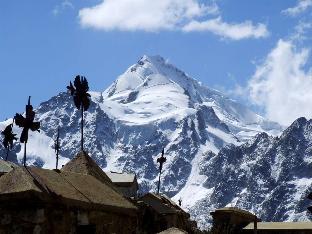
Huayna Potosì from the road out of El Alto
When we got back from Uyuni, we checked out a nifty little website called MountainWeather.com, which gives the predicted forecasts at various altitudes for mountains all over the world, including Huayna Potosi. We had hoped to have a day or two rest in La Paz, but it looked like the weather was getting much worse (very high winds predicted) as the week progressed, so we decided to take just a one day turnaround and leave on that Monday.
We spent the day gathering supplies for the climb. Luckily, we had prepared most of the gear we needed to rent the week before from our friend Cristian at an agency called Andean Base Camp. He had been unbelievably helpful in our planning of this climb as well as our trip on the Choro Trail and was an all around great guy. He never seemed to stear us wrong, be it with what gear to bring, what campsite to stay at, or even where to eat lunch. He was just one of those great, truly helpful people.
Anyways, Cristian decked us out in everything we needed: crampons, snow pants, mittons, ice axes, helmets, sleeping bags, rope, harnesses, etc. Moreover, he also told us where we could cheaply buy things like down jackets and face masks - saving us money and losing him money in the process. Again, definitely a guy that just wants to help.
Packing up our fully loaded packs at the trail-head
With all our gear, we picked up some food, mostly bread, manjar, some fruit, etc. We spent the rest of the day resting and got a good night sleep, knowing that the following day would be a long one.
We woke up fairly early on Monday morning and headed to Cristian´s to pick up our gear. While we were in the shop, there also happened to be a taxi driver returning from picking someone else up from the mountain who offered to drive us there. The price seemed like a lot, but given that it was a two hour drive over difficult roads and he most likely wouldn´t get a return fare, we figured it was just. We loaded our now bursting and heavy packs into the trunk of the cab and we were off.
About ten minutes down the road, Sam had a lucky moment where he realized that we had never tried on or packed our crampons. Without these, we never would have gotten past base camp, so it was a great stroke of fortune that we remember this early. Finally, now with fitted crampons, we made a second take and headed up, up, up out of the city.
The drive took us out of La Paz and into the major suburb of the city, El Alto (literally, ¨the high place¨). El Alto appropriately sits on the plateau overlooking the valley where La Paz sits nestled under the imposing massif of Illimani, a 21,000 ft dormant volcano. The town is huge and sprawling, but markedly less developed than La Paz. The houses are mostly made of mud and brick, many lacking basic ammenities like windows or electricity. It´s a place that most tourists never visit, so it was interesting to be able to see what it was like, even if we were only passing through in transit.
We were delayed by a huge market day that had seemed to take over the street we were trying to navigate, but finally made our way to the other side of town. All of a sudden, the houses abruptly stop and the road is left surrounded by the scrubby, high alpine grass of the
altiplano. The road snaked up towards the snow-capped
nevados which were beginning to poke over the horizon. As we continued up through the grasslands, the road deteriorated, going from pavement, to cobble stones, to a simple dirt path. We passed small farmhouses with herds of llama and alpaca and sheep before finally coming to a ridge where our cab driver pointed to a daunting snow-covered pyramid ahead of us.
¨
Alla está Huayna,¨ he said. ¨There´s Huayna.¨
The road then dropped into the valley in front of the mountain and we skirted the side of a spectacularly blue lake and up a precipitously, breath-taking ridge. We passed a cemetery, which our driver told us was full of men who had died in mining accidents. A few minutes later we passed a town which looked right out of the wild west. Rusted corrugated steel roofs covered dilapated buildings which sat along empty streets. Giant oxidized mining machines sat seemingly unused for decades. It seemed suddenly clear why there were so many protests in the Andean nations about mining conditions.
The miners´ graveyard with Huayna in the background
After a long, hot, bumpy ride, we finally arrived at the trail head at about 4000m above sea level. We unloaded our gear and negotiated for our cab driver to meet us there the following day at about noon. It was now about 1pm. We had less than 24 hours to climb and descend a vertical mile and a half over rock, ice, and snow. After a quick snack, we were off.
Getting ready to head off from the trail-head
The hike to base camps are often surprisingly difficult. Despite being well-rested, well-fed, and full of energy to start the trip, this is the time when the packs are at their fullest and the weight can be challenging and cumbersome. This particular hike was no exception. With the mid-day sun out, we were sweating within a few minutes of starting and were reduced to pants and t-shirts, leaving the rest of our heavy, snow-climbing gear on our backs. Between that and a few thousand calories worth of food, we were really feeling the weight.
Luckily, the path was clear and the terrain was fairly easy for the first hour or so. We climbed gradually through a boulder field and up to a ridge where we then descended into the valley formed by the enormous glacier slowly sliding off the side of the mountain. We dropped into the carved out valley, crossed a few small glacial streams, and then began the long climb up towards the
refugio, where we would be stopping.
 |
| Sam with on the hike up to base camp, the glacial valley in the background |
We climbed up a short, steep face onto a long ridge which led up to the side of the mountain. Following this, we could see a trail of switch-backs leading up a steep rock wall towards the snow line. We knew that the
refugio was very close to the glacier line, so we figured we must be pretty close. We stopped for a quick snack and rest before starting up what we figured was the final few hundred meters of ascent.
 |
| The narrow ridge before the switch-backs. The refugio is on top of the ridge in the top right. |
The trail here became very tough. We were climbing steeply up towards the snow-line and were beginning to feel the effects of the high altitude coupled with exhaustion from a few hours of carrying heavy packs over difficult terrain. As we got higher, the path became dotted with patches of snow and the going became much slower. The snow made the rocky path wet and treacherous, as we now had to carefully place our weight on each step so as not to slip and fall down the several hundred meter cliff face. It was tiring, but we could see people on a ridge above us, and figured that must be where we were going.
As we continued up, the snow became more and more prevalent. Suddenly, instead of rocks with patches of snow, we were walking on snow with patches of rocks. The snow was hard and icy and our trekking boots were continuously slipping, failing to get any traction on the hard surface. I considered putting on our crampons and roping up, but we could see the
refugio only 100 feet or so above us, and it seemed crazy to change boots and all just for these last few minutes. We managed to leap-frog from rock to rock and use our ice axes as added traction and finally found ourselves at the top of the ice face, finally on flat ground. The
refugio was right in front of us and we were happy to sit down, take of our packs, and breathe a welcome sigh of relief.
 |
| Finally made it. 5130m above sea level. |
 |
| Sam taking a breather just below the refugio. The terrain was tough. |
It had only taken a few hours, but the toll had been greater than either of us had expected. It was probably about 5pm, which gave us about 8 hours to rest, practice some basic snow travel, eat, get some sleep, wake up, and head off for the summit at 1am. Like all other glacial climbs that I´d undertaken, the typical way that expeditions reached the summit of Huayna Potosi was to leave in the VERY early morning (between midnight and 2am, generally), climb up in the dark, and arrive at the summit around sunrise. The reason for this style of climbing is that the snow on the glacier becomes much harder at night and is much easier and less draining to walk on. During the day, the top layer of the snow can melt from the strong sun, creating a wet, soggy mess, which can be akin to walking through sand. Moreover, if there are sections of loose snow or snow-bridges over
grietas - crevasses - these can become too soft to cross during the hot, mid-day sun. Despite the pain of waking up in the middle of the night, it ends up being easier and safer, so this has become the norm for these types of climbs.
After a brief rest at the
refugio, we put on our boots, crampons, and harnesses and headed out to the glacier for a bit of practice before it got dark. One of the great things about this refugio was that it was literally just a few meters from the edge of the glacier. Usually, base camp sites are an hour or so´s walk to the edge of the glacier. This can be frustrating because the big mountaineering boots are generally not great at navigating the rocky boulder fields which are usually right below the glacier line. Luckily, here, we only had to walk out the door of the refugio and put on our crampons.
 |
| Looking up the glacier at the setting sun |
Sam took to the glacier fine and we only spent a few minutes going over basic walking techniques and some safety guidelines. The snow was hard and the trail seemed very clear, so it seemed like everything was conspiring in our favor. The skies were clear and not too windy and the temperature was still reasonable, despite the setting sun. It seemed like a good night for a climb.
We made our way back to the
refugio and made up a quick dinner before going to bed. The high altitude (the
refugio sat at 5130m above sea level) killed our appetites a bit, but we forced ourselves to try to eat as much as we could, since we knew that we´d need it for the hours ahead. We got our gear laid out so that all we had to do was get up and get dressed and have some breakfast in the morning. We chatted a bit with the other guides and climbers - there were probably about a dozen other people there with us - and decided on a time to set off. We figured we´d let the guided groups go first so we could follow the light of their head-lamps if we ever couldn´t follow the route. Finally, we cralwed into our sleeping-bags on our cots and tried to get some rest.
 |
| A simple dinner and some relaxing before a long night on the mountain |
 |
| The surrounding mountains being cast into shadow as the sun set over Huayna |
The few
hours we spent trying to sleep were pretty brutal. We were so high up and there
was so little oxygen in the air that I simply couldn´t sleep. I´d camped high
before, but never above 5000m. Here at 5130m, I counted my resting heart rate
at over 100 BPM (usually in the 40s, even at altitude) as I was trying to fall
asleep. I would feel my breathing begin to calm and as I would start to drift
off to sleep, I suddenly found myself gasping for air and wide awake again.
I don´t
think I got any real sleep, but I was able to rest finally for a couple of
hours. Around midnight, we started to hear a lot of movement as the other
groups began to stir. I stayed in the warm down comfort of my sleeping bag for
a while longer and finally decided to get up and start getting ready a bit
before 1am.
I was a bit
concerned as I headed outside. As I´d been sleeplessly lying in my cot, I had
heard the wind whipping and screaming through the corrugated steel roof of the
hut. Afraid that I´d be greeted with similar winds to last year´s climb up
Cotopaxi in Ecuador (where we were forced to turn back due to 100mph winds), I
stepped out into the cool night with trepidation.
Luckily, I
was actually met with fairly calm winds, clear skies, and moderate
temperatures. The wind had either died down or its sound had simply been
amplified by the loose roof right above us. I talked to a few of the guides,
who had been very friendly with us the night before, and got some more info on
the route. Apparently, it was a very simple and easy to follow trail because of
how much traffic the peak saw, just as I had expected. He told us that,
technically, the climb was simple: just a long walk until the final summit
ridge, which was a fairly exposed and narrow climb for the final 200m vertical
meters or so. No surprises.
 |
| Sam getting ready to go |
The guides
were also nice enough to let us use their stoves to melt some snow so that we
could have some hot coffee and some drinking water for the climb. Our friend
Cristian back in La Paz had told us that we wouldn´t need a stove, that there
were always stoves you could use (usually for a small fee) at the refugio. These guys were nice enough
that they let us use their gear for free, though, so we had a nice breakfast of
bread, chocolates, and hot coffee. We were the last party to leave, but we met our
2am planned departure. With our harnesses on and a short length of rope between
the two of us, we made the quick walk to the edge of the glacier where we put
on our crampons and stepped onto the glacier.
The climb
itself was supposed to take 4 to 7 hours. We figured that since we were already
pretty well acclimatized and since we were fairly fit, we should be close to
that 4 hour mark. So, as we left and the headlamps of the other groups seemed
impossibly far in front of us, I wasn´t particularly worried. The trail was
very clear and easy to follow, as promised, and we made consistent and good
time.
The weather
was near perfect. There was no wind whatsoever, the skies were beautifully
clear, with the stars brightened by a new moon, and the temperatures were
remarkably comfortable. Within an hour, I had stripped off my parka and other
warm layers and was walking in just my snowpants and a t-shirt and fleece. We
joked that we were warmer here than in our hostel in La Paz, which was
notoriously dark and cool. Spirits were high as we continued climbing through
the pitch black night.
Eventually,
the headlamps up ahead became closer and closer and we began to pass the groups
which had left ahead of us. The altitude didn´t seem to be bothering us and our
appetites were still quelled enough that we only stopped a few times for water,
so we made good time. The walk was mostly a gradual uphill climb, with the
occasional traverse across a flat section of glacier. In those first few hours,
we only encountered one relatively steep section, which required use of the piolet - ice ax - and front points of
the crampons. Otherwise, it was smooth sailing.
Within a
couple of hours, we had passed all of the other groups and were the first ones
heading up the trail. It was still clear from the continuous daily traffic, but
I would have been happier if there were still guided groups in front of us. But
the trail was so obvious and clear and I wasn´t too concerned. We soldiered
onwards.
As we got
higher and higher, the altitude began to take its toll. Around 5am, still pitch
black, the going got particularly tough. We got into a very slow rhythm of
step, step, step, step, pant, pant, pant, pant. We were moving at a snail`s
pace, but the groups behind us were still out of sight.
Altitude
can have interesting effects on the brain as well as the body. One thing I´ve
experienced a few times when climbing at very high altitudes is a sort of
borderline hallucination where my brain starts to recognize shapes in the ice
flows and windswept surface of the glacier. I specifically remember when
climbing Chimborazo – the tallest mountain in Ecuador – seeing huge pillars of
ice near the summit and seeing carved faces and statues in them. In retrospect,
it seems silly, but at the time I really couldn´t decide if these were carved
totem poles or if they were just random ice flows.
 |
| The long path was hidden in the darkness of the night. |
As we
approached the summit ridge, I began to see shapes in the surface of the
glacier. Everywhere I looked, the chaotic pattern of ice and snow was forming
into faces. I was tired, physically, but felt perfectly aware and alert other
than this. It was an odd sensation, though, so we stopped for a few minutes of
rest.
Here, we
had the only minor problem of the climb thus far. I had taken off my large
mittens so I could negotiate the zippers of my pack to get at my water and some
chocolates. As I stood with my mittens stashed between my knees, as usual, a
gust of wind picked up and suddenly one of my mittens was sliding down the face
at an alarming rate. It happened way too fast to try to grab it and, though I
could see it maybe a hundred feet down, it was still too dark to see what the
snow was like down there. It wasn´t my mitten and I wasn´t psyched about the
idea of having to buy a new one, but it wasn´t worth falling into a crevasse or
off a cliff´s edge just to get it.
The good
news was that I still had my gloves which I was wearing under the big mittens.
The air was still surprisingly warm and I felt that if we kept moving, I´d be
able to make it up with just one mitten and the gloves on the other hand.
Moreover, we could see the mitten sitting right below the trail, so I figured
we could ask one of the guides if this snow was safe and grab it on the way
down. It wasn´t an ideal situation, but it seemed reasonable. We were on our
way again.
The
climbing – really just walking, still - continued to be a tough slog. I hadn´t
looked at my watch, but it was still pitch black out, so I figured we must
still have a long way to go. It was getting a bit colder too, as we got higher,
and I had to blow hot air on my right hand every minute or so to keep the
feeling in it.
To both of
our surprise, the path quickly steepened and suddenly we found ourselves on the
top of a razor-thin ridge. As we crested the ridge and exposed ourselves to the
eastern face of the mountain, we were buffeted with an enormously powerful
wind, which nearly blew us off of the face right there. It was an intense wake-up
after slogging up the gradual, gentle uphill through the calm air for the last
4 hours and really got our adrenaline flowing again.
I was a bit
concerned as I didn´t see where the trail went from where we were, but I
figured this must be the summit ridge that people were talking about. It had
been called narrow and exposed, which it certainly was, so this must be it and
we must almost be there.
As I shined
my headlamp farther up the ridge, I thought I could see the trail up ahead. All
that lay between us and the trail was a section of VERY thin, rocky ice. I assumed
that this was it and made my way from the sturdy ledge where we had stopped out
onto the thin, exposed, windy ridge.
Right away,
I was having thoughts that this might not be the right idea. I first had to
traverse around the ridge and was then faced with a 15 foot nearly vertical
climb up a wall of ice. I couldn´t help but look down and saw that we were now climbing
on the exposed Eastern face of the mountain, with nothing but the one point of my
piolet and the four points on the front of my crampons keeping me from falling
1000m down into the blackness below. I got myself to just focus on the task at
hand: thwacking my piolet into the snow and ice, making sure it was stable and
secure, and then moving my feet up, one by one, inching my way up the face.
Finally, I
reached the top of the paredcita –
little cliff. Much to my dismay, we were not at the path I had seen before
going up the ridge, but were sitting atop an extremely narrow and unstable ridge
or rock and snow. I could see the path up ahead, probably only 10 or 15 meters
away, but between my spot and there was only more of the same unstable ridge.
As I looked
down, I could see where we had gone wrong. A set of steep steps had been carved
into the ice which were now obvious when seen from above. We had passed by
these in the dark and ended up on the wrong side of the ridge. As I sat
straddling the unstable 6 inch ridge, with Sam dangling below me, still hanging
from his crampon points on the ice, I realized we had to make a decision.
Either we had to try to get across this ridge and back to the path, or we had
to descend back down the exposed ice cliff and retrace our steps until we were
back on the real trail.
I looked at
both options, and as much as I didn´t want to descend back down that exposed
face, the ridge in front of us just looked too unstable and dangerous. I knew I
had to make a decision quickly, since our current predicament did not feel particularly
secure. I decided we should retreat.
Descending
back down the cliff was a bit hair-raising, knowing that there was nothing
under us but 1000m of ice. I let Sam go first, doing my best to secure myself
and belay him down with the short length of rope we had. After a few hair-raising
meters, we finally traversed back to the other side of the ridge, where we were
sheltered once again from the wind and could catch our breaths and relax, on
solid ground once again.
By this
time, a few of the other groups had caught up to us, so it was obvious where we
were headed. The summit looked so close and light was beginning to peak over
the mountains to the east. We were so pumped full of adrenaline from our mis-adventure
on the ridge that the altitude didn’t seem to matter anymore. I didn´t feel
tired or exhausted, I just wanted to keep going.
We climbed
up the steep steps that we had seen from above and finally found ourselves on
the right side of the ridge. We were still pummeled by the wind, but at least
now we were on the right path. The trail was still unbelievably narrow with a
steep, enormous drop off on either side, but the summit was in sight. We
carefully made our way up, using our ice axes for added balance and security. I
was only looking at the meter or so in front of me, and so I was surprised when
we finally reached the summit and there was nowhere else to go up.
 |
| Tyler relaxing on the summit after an adrenaline-filled last hour |
We sat down on the small summit, high-fived
some of the other climbers and guides and watched the beautiful sunrise over
the stunning Cordillera Real. Huge,
jagged, snow-capped nevados were
illuminated all around us. We could see the sprawling metropolis of El Alto far
below us and even bits of La Paz in the valley below. Far to the south, we
could make out Sajama, Bolivia´s highest
mountain, hundreds of kilometers to the South. Closer to us, the towering
massif of Illimani which stands guard
over La Paz, was lit up in the morning sun.
 |
| Sunrise on the summit. Clouds over the jungle to the east. |
We tried to take a few photos, but had trouble.
The cold on the summit had killed both of our lithium batteries. We could get a
few minutes of use by blowing hot air on them, but unfortunately, we didn´t get
too many pictures from the very high ridge and summit. Similarly, our
camel-back straws had frozen solid, so we were unable to drink any water. We
decided we´d better get back down to where it was warmer. We only had about 5
hours until we were supposed to meet our friend, the taxista, back at the trailhead.
 |
| Sam sitting on the summit ridge. The super-narrow ridge can be seen behind him. |
 |
Sam on the summit
|
The descent was much simpler and quite lovely. The
ridge was tricky again (and almost scarier in the light of day), but we managed
to get down to the main trail without any trouble. From there it was just a
long, gradual walk down the glacier back to the refugio.
It´s always nice descending after a night-time
summit because of all of the enormous crevasses and ice formations which
suddenly become visible. Huge bowls, fields of crevasses, and giant icicles
surrounded us in a huge snowy expanse.
 |
| Ice formations on the way down |
As we made our way down the trail, we saw the
spot where my mitten had fallen and decided to go down the trail a bit, where
we could see a group of French climbers with a guide, and ask if it would be
safe to go get it. The guide said that it was fine, that the glacier was solid
and not crevassed in that section, so we made our way back up the trail to
where we could build an anchor and I could repel into the gully to fetch it.
Sam, a bit exhausted, sat down in the center of
the trail while I tied him into an anchor and gave myself about 20m of rope to
descend with. He belayed me down the steep face of the snow-bowl and I made my
way to where my mitten had sat alone for the last few hours. We had no
problems, but it had taken a while to set up the anchor and belay, so we were a
bit behind all the other groups now.
 |
| The long walk down the glacier. The road and refugio still hidden from view. |
 |
| Walking down the glacier. Illimani towers over La Paz in the background |
We made decent time for the rest of the descent,
though. The scenery and views were spectacular in the early morning sun and the
air had become a pleasantly warm temperature. After a few hours of down climbing,
we finally reached the last face and walked down to the edge of the glacier,
where we sat down on the rocks next to the refugio
and took off our crampons and breathed a long sigh of relief.
We took a quick rest inside. It had taken us
longer than we´d planned to get down because of the mitten rescue mission, though,
so we didn´t take too long. After a bit of food and re-loading all of the gear
into our packs, we were on our way down to the road.
The initial descent was actually very tough. I
had opted to wear my big boots and crampons for this first part, since it had
been so snowy and icy on the way up, but the going was still tough. The snow
and ice were mixed in among rocks, so the crampons kept sliding and catching
rock. It was frustrating and tough and I was exhausted from being awake for 30
hours and spending a great deal of them climbing.
We managed to make it down that steepest part
of the trail and so the last hour or so was much easier. The trail was just a
dirt path through the glacial valley and we made it down and out without
incident. The wind which we´d felt on the summit ridge seemed to have increased
and come down the mountain though, because we were nearly blown over several
times in this last section of the hike. I was glad we were almost done and not
just starting out. It looked like conditions were going to deteriorate a lot
over the coming hours and days. We´d gotten pretty lucky.
As the road came into view, we saw our buddy
waiting for us. It was just after 12pm, so we were just on time by Peruvian
standards. He helped us load our big packs into the cab and we grabbed some
food out of them and crawled into back seats for the two hour journey back to
La Paz. I was glad we´d both seen the scenery on the way out, because I think
we were both asleep as soon as the engine started.